
Efeoglou Elena, Laboratory Teaching Staff, School of Film, Faculty of Fine Arts, Aristotle University of Thessaloniki, GR.
Photograph’s date: 1) March 2, 2018; 2) April 20, 2018; 3) March 2, 2018; 4) March 2, 2018; 5) May 5, 2019.
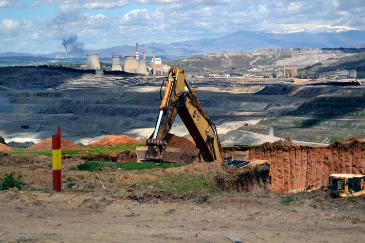
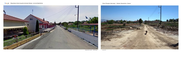
More than 50% of electricity in Greece is produced in the area of Western Macedonia, in Northern Greece. It is the largest lignite mine in the Balkans, which is constantly working 24 hours a day. The villages located in this area have lignite in their subsoil and for this reason, they are gradually being destroyed while the residents are obliged to evacuate them. The residents were pushed to give up their plots and their homes and they receive financial compensation. Lignite mining destroys thousands acres of arable land and gradually it eliminates the villages.
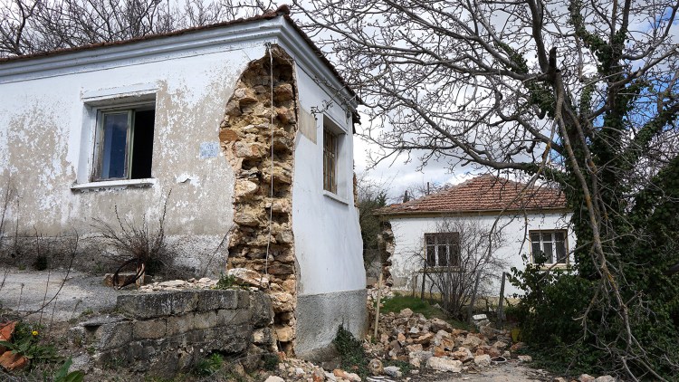
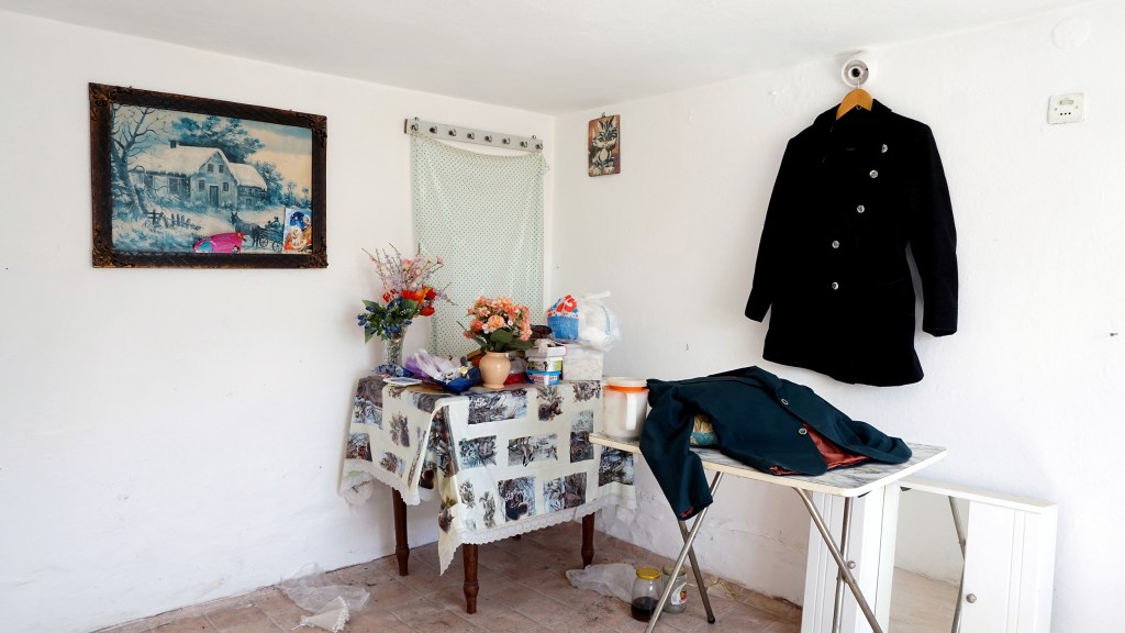
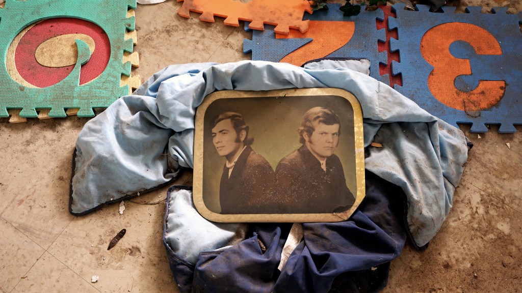
The project Dislocations describes the gradual disappearance of a village called Mavropigi. My photographic research began two years ago when most of the residents have left their homes. They left behind personal items, photos, clothes, toys and much more. The village remained as a ghost waiting for its demolition. Gradually the mine expanded and the houses began to be demolished, deleting any trace of previous life. The project comments on the privatization of the national resources and of the land.
Why are those particular photographs important to your research?
Mavropigi is a village that is gradually disappearing. There is a huge social and environmental cost, which comes from the constant need for financial gain and the growing demand for energy consumption. The long-term impact of lignite mining on residents’ lives and the environmental balance is remaining invisible. Residents who have already abandoned the village face the immediate consequences on their daily lives by looking for new homes and new life in nearby cities.
The aim of this project is to record the abandoned village in the state of devastation and to highlight the transformation of the landscape. For this purpose, I visited the village four times to take pictures (2017-2019). In order to describe the current situation i have paired the present images with the same images derived from the Google Maps and I compared the photographic material. The images of the application can be a tool in traditional social crawling methods. The village remains only as a virtual place in Google maps and although the visitor of the application may be able to navigate into the streets the reality is that the village has disappeared.
Dislocaciones
Efeoglou Elena, Laboratory Teaching Staff, School of Film, Faculty of Fine Arts, Aristotle University of Thessaloniki, GR.
Fechas de las fotografías: 1) 2 Marzo, 2018; 2) 20 Abril, 2018; 3) 2 Marzo, 2018; 4) 2 Marzo, 2018; 5) 5 Mayo, 2019.
Más del 50% de la electricidad en Grecia se produce en la zona de Macedonia occidental, en el norte de Grecia. Es la mina de lignito más grande de los Balcanes que trabaja constantemente las 24 horas del día. Las aldeas ubicadas en esta zona tienen lignito en su subsuelo y por ello se están destruyendo paulatinamente mientras los vecinos se ven obligados a evacuarlas. Los residentes fueron presionados para que renunciaran a sus parcelas y sus casas y reciben una compensación económica. La extracción de lignito destruye miles de acres de tierra cultivable y gradualmente elimina las aldeas.
El proyecto Dislocaciones describe la desaparición gradual de un pueblo llamado Mavropigi. Mi investigación fotográfica comenzó hace dos años cuando la mayoría de los residentes abandonaron sus hogares. Dejaron atrás objetos personales, fotos, ropa, juguetes y mucho más. El pueblo quedó como un fantasma esperando su demolición. Poco a poco la mina se fue expandiendo y las casas comenzaron a ser demolidas, borrando cualquier rastro de vida anterior. El proyecto comenta la privatización de los recursos nacionales y de la tierra.
¿Por qué es importante esta fotografía en particular en su investigación?
Mavropigi es un pueblo que está desapareciendo gradualmente. Existe un enorme costo social y ambiental que proviene de la constante necesidad de ganancias financieras y la creciente demanda de consumo de energía. El impacto a largo plazo de la extracción de lignito en la vida de los residentes y el equilibrio ambiental sigue siendo invisible. Los residentes que ya han abandonado la aldea enfrentan las consecuencias inmediatas en su vida diaria al buscar nuevos hogares y una nueva vida en las ciudades cercanas.
El objetivo de este proyecto es registrar el pueblo abandonado en estado de devastación y resaltar la transformación del paisaje. Para ello visité el pueblo cuatro veces para tomar fotografías (2017-2019). Para describir la situación actual, emparejé las imágenes presentes con las mismas imágenes derivadas de Google Maps y comparé el material fotográfico. Las imágenes de la aplicación pueden ser una herramienta en los métodos tradicionales de rastreo social. El pueblo permanece solo como un lugar virtual en los mapas de Google y aunque el visitante de la aplicación puede navegar por las calles, la realidad es que el pueblo ha desaparecido.
